CROSS THE ATLANTIC IN SHORT HOPS

By: Yachting World
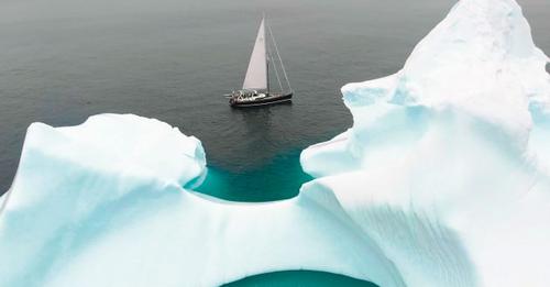
Photo: SailCA
If a non-stop eastbound Atlantic crossing seems daunting, there may be another option, which offers shorter periods at sea and spectacular scenery, but brings its own challenges…
An Atlantic crossing is – rightly – considered a bit of an epic. An east-bound crossing, often even more so. But by following the seafarers of old, on what is pleasingly known as the Viking Route, it’s possible to cross from tropical Florida or metropolitan New York to Europe with less than a week at sea at any one time.
That’s not to say it’s an easy option. A high latitudes voyage into the North Atlantic demands respect and serious preparation to sail in remote areas with increased risk of severe weather and sea ice. But the rewards can be spectacular.
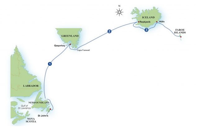
Alberto Duhau sailed his Hylas 63 Shaima from Florida to the Mediterranean one summer, by heading north along the east coast of the US, across the North Atlantic via Newfoundland, Greenland and Iceland, then south to Europe via the Faroe Islands. Here’s how he did it:
Newfoundland to southern Greenland
During July, high pressure is typically centred just south-west/west of the Azores with ridging extending south-west/west towards Bermuda. There is a weak high over Greenland, with low pressure generally over north-east Canada (Baffin Island to northern Quebec) and near Iceland.
To the north of the Azores high, the prevailing winds are west/south-west for much of the way to Iceland. Wind is usually stronger south of the rhumbline, and lighter to the north. July offers the lowest chance of gales, but occasionally stronger lows develop and move east/south-east from eastern Canada.

Greenland to Iceland
For this passage the main concern is the north-easterly wind near Greenland’s Cape Farewell. If the Greenland high pressure system is stronger than normal, beware of north-easterly winds along the south Greenland coast of 25-30 knots plus.
Expect light conditions heading east toward Iceland. If south of the rhumbline, there is greater chance of stronger westerly/south-westerly winds, while a northerly route is more likely to encounter north-easterly/easterly headwinds.
Around Iceland and to Faroes
Circumnavigating Iceland at the end of July and beginning of August is the optimum timing with the smallest threat of gales, but you may have to wait out bad winds for a day or two for a window.
The roughest weather is associated with low pressure passing to the west, north-west, or west, which correspondingly means the strongest winds are south-westerly, westerly, and north-westerly.
Avoiding North Atlantic storms and ice
Alberto Duhau enlisted the advice of expert meteorologists in advance of his north Atlantic trip. He knew the voyage was possible in good conditions, but wanted a second opinion regarding timings.
Research revealed that the region’s quietest weather historically occurs between mid-July and the first 10 days of August. However, settled conditions can run from late June to the end of August. Autumn develops earlier the farther north you are, so it is generally a good plan to turn south by the second half of August.
Duhau also contacted the well-known expedition support High Latitudes for help with ice routing between Newfoundland and Iceland. Founder and experienced pilot Magnus Day joined the crew for this part of the cruise.
“Ice is possible anywhere from Nova Scotia to about 150 miles south and east of Cape Farewell,” Day warns. “All ice should be regarded as dangerous to small vessels.”
Ice charts are available from the Canadian Ice Service (ice-glaces.ec.gc.ca) and the Danish Maritime Authority (dma.dk) and are useful as a guide, but must not be relied upon. Radar is also a useful tool, but it may not pick up even large pieces of ice in certain conditions.
Ice in the Labrador Sea will usually be thicker along the Newfoundland and Greenland coasts. Commanders’ Weather recommends heading due east until around 45°W, then turning north.
Magnus Day broadly concurs. “A wise tactic to lessen the chances of encountering ice is to head square offshore until outside the reported ice zone, then more or less parallel to the axis of the Labrador Sea until adjacent to your destination, before turning in square to the shore again.” He recommends motoring if the wind is light.
Day’s other top tips include:
- Have one or more crew outside on deck paying close attention for ice at ALL times.
- Ideally have two crew rotating on every watch – one on deck keeping a visual lookout while the other keeps a radar watch and makes the coffee etc. Roles should be swapped as regularly as every 15 minutes to help maintain levels of alertness.
- Ask passing vessels if they have seen any ice locally. Likewise, when in port talk to locals and ask them what they’ve seen recently and if there are areas locally which collect ice.
- Crew need to be dressed to stand outside in freezing temperatures with wind and waves coming over the deck for long periods of time. Think about how you can create shelter for them on deck.
- Never drop your guard. It only takes one piece of ice to bash a hole in your hull as you fall off a wave.
Expert advice for ice regions
Commanders’ Weather has been advising sailors about optimum weather routing for over 25 years. Their expert meteorologists have supplied forecasts for cruisers and racers, including the SailGP circuit, Olympic sailing teams and Comanche’s 2016 Atlantic record. See commandersweather.com
As well as pilotage, High Latitudes has the expertise to plan itineraries in both polar regions, secure the necessary environmental permits, offer logistical support and work on modifications to suit a yacht for ice. See highlatitudes.com


